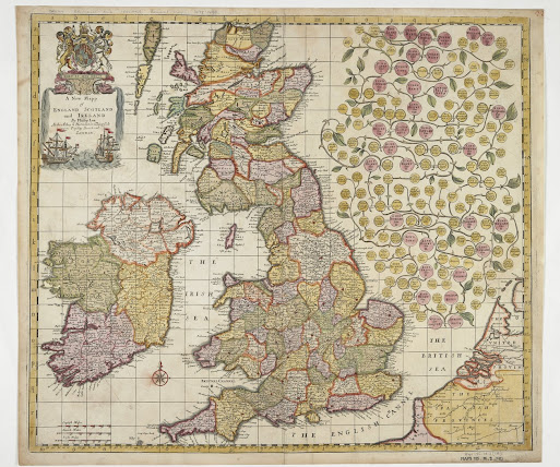
1678 MORDEN, Robert
Illustration courtesy of the Trustees of the British Library (state 4 Maps 185.m.2 (18)).
The map of the British Isles published by Robert Morden together with John Overton in 1678 is most unusual as it presents a large royal family tree to the right of the map. Based on Morden and Greene´s six-sheet wall of 1674 it has been improved by showing a better outline to the Irish coast. Whereas most maps which showed roads had not shown them north of the Scottish border, a few roads are illustrated going up the east coast. The family tree begins with William the Conqueror and ends with King Charles the II and Queen Catharina together with King James the II with Queen Mary. The corner extreme top right is blank.
A New Mapp
of England Scotland and Ireland Sold by Robert Morden at the Atlas in Cornhill
By John Overton at the White Horse without Newgate London. The title in a panel surrounded above
by the royal arms and below by two warships engaged in battle, the sides
completed by water cascading down from the mouths of two sea creatures. Size:
515 mm x 585 mm. (C).
Later states in
1685: Overton´s name replaced to read and By Phillip Lea at the Atlas and
Hercules in Poultrey and by John Seller at the West side of ye Royall
Exchange London.
c. 1687 Lea´s
address is now given as Atlas and Hercules in Cheapside, while Seller´s
is West end of St Pauls at ye Signe of the Mapp of the World. Squeezed
in between Charles and Catharina are two small additions referring to Mary
married to the Prince of Orange and Anne married to George of Denmark. (BL,
Admiralty).
c. 1690 with
only Lea´s imprint. The corner extreme top right is now taken up with King
William the III and Queen Mary the II replacing Mary´s previous roundel. (BL,
illustrated).


Comments
Post a Comment