1654/1655 PORTER, Thomas and WALTON Robert
An ambitious work appeared in 1655 with the publication of Thomas Porter´s small pocket book. Although made portable for every mans pocket it included a complete map of the British Isles as well as copious information for travellers of all kinds. The title of the book, although referring to a Booke of Maps, only included this one map.
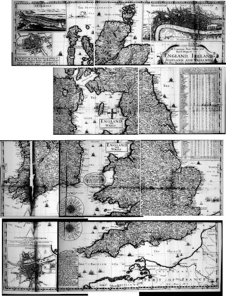
A Curious New and Plaine and Exact Mapp of England, Ireland, Scotland and Wales was engraved by W Hollar and printed in 1654 by Robert Walton. This large map was based on the work of John Speed (noted in title as I.S.) and inlarged by G.H. (presumably George Humble, one of Speed´s publishers).[1] The map was to be sold at Walton´s shop at the West end of Paules in Iuuy Lane. The map consists of two plates, of unequal size, joined together. (BL). The original map is now in its two pieces separately. A Curious New Plaine and Exact Map is either an attractive map or a cluttered map depending on your point of view. With scenic views in the top corners of Edinburgh and the Thames River and a plan of Oxford. In the bottom left corner is a lan of Dublin. A Catalogue of the Shires, Hundreds, Citties etc is off the east coast while an attractive compass rose nestles between southern Ireland and Cornwall. There are no roads.
Two later states are known, both undated but dated to approx.. 1658-1666. The first has a new address Printed for & by Ro. Walton and are to be sold at his shop at ye Globe and Compass between ye two north dores of St. Paules (
B) and the second is in a circa 1660 edition of Porter´s work. This has a double circle around the scale and compass (
B).
By Thomas Porter. To be sold by Robert Walton... West End of S Pauls, 1655. (
BL, PSL).
All illustrations courtesy of Internet Archive. Original in British Library. The map illustration is a composite of various pages scanned from the online .pdf and only to give an idea of the scope of the map.The book contained a series of tables – Wherein Are,
I.
Alphabeticall Tables, shewing the
Longitude and Latitude of all the Towns named in the Said Maps; with easie and
ready directions how to find any of them, though you know not in what parts
they lie.
II.
Tables of the High-wayes in England,
Wales, and Ireland, Alphabetically methodized, which hath made them very
plaine.
III.
Tables as easie as an Almanack, which
may supply the use thereof for 100 Yeares, that is to say, from Anno 1600- to
1700.
And Other
Usefull Tables. By Thomas Porter. This Book being necessary for all men, it is
therefore made portable for every mans pocket. Licensed, and entred according
to the late Act for Printing.
Thomas Porter also issued The Newest and Exactest Mapp of the most Famous Citties London and Westminster with their Suburbs; and book on cosmography with Walton.


Comments
Post a Comment